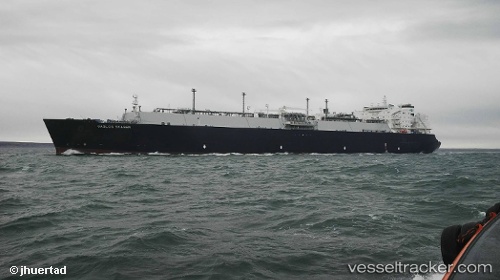
vessel Gaslog Skagen IMO: 9626285, Lng Tanker
vesseltracker.com
Vessel Gaslog Skagen IMO: 9626285, Lng Tanker
MMSI: 310664000 callsign: ZCEJ7 size: 45x285

Find the position of the vessel Gaslog Skagen on the map. The latter are known coordinates and path.

marine traffic ship tracker show on live map

The current position of vessel Gaslog Skagen is 31.7844 lat / -11.2505 lng. Updated: 2025-07-30 15:58:11 UTC
Details:


Last coordinates of the vessel:
UTC, 32.2473, -10.7275, course: 227, speed: 10.8
UTC, 32.104, -10.8888, course: 229, speed: 10.8
UTC, 31.8812, -11.1556, course: 227, speed: 10.9
2025-07-30 15:58:11 UTC, 31.7844, -11.2505, course: 198, speed: 10.9

Track of the vessel in the last 14 days


The ship also appears on the maps:


Most frequent ports a vessels calls at Gaslog Skagen (310664000):

Barrow Island, traffic: 13
Sambu, traffic: 13
Singapore, traffic: 11
Johor, traffic: 6
HITACHINAKA, traffic: 5
Strait Of Gibraltar, traffic: 4
Yokohama, traffic: 4
Yokosuka, traffic: 4
Kawasaki, traffic: 3
Selat Lombok, traffic: 3
Port Darwin, traffic: 3
Darwin, traffic: 3
LAVERA, traffic: 2
Ostrica, traffic: 2
Chibai, traffic: 2

Link to the map:


Find another ship

Gaslog_Skagen (310664000) last ports (portcalls and passsages)

TARIFA | 2025-07-29 02:54:29
Livorno | 2025-07-24 17:09:01
Strait Of Gibraltar | 2025-07-22 10:09:26
SABINE PASS | 2025-07-09 06:26:03
BRUNSBUETTEL | 2025-06-07 10:45:39
Cuxhaven | 2025-06-07 10:08:49
ARANSAS PASS | 2025-05-20 11:47:47
Strait Of Gibraltar | 2025-04-29 10:42:10
SAINT LOUIS DU RHONE | 2025-04-26 10:50:35
PORT DE BOUC | 2025-04-25 11:23:25
LAVERA | 2025-04-21 11:22:23
Alicante | 2025-04-19 22:19:00
TANGER MED | 2025-04-18 14:44:53
Strait Of Gibraltar | 2025-04-18 13:34:38
CAMERON | 2025-04-07 00:24:43
Calais | 2025-03-17 23:13:36
Myrtle Grove | 2025-02-26 13:14:03
Port Sulphur | 2025-02-26 11:29:12
EMPIRE | 2025-02-26 10:28:03
Kingston | 2025-02-01 04:27:31
JURONG ISLAND | 2024-12-12 04:50:06
BUKOM ISLAND | 2024-12-12 04:05:51
PULAU SAMBU | 2024-12-12 02:22:26
TANAH MERAH | 2024-12-12 01:12:08
PENGERANG | 2024-12-11 23:27:09
Yokohama | 2024-11-27 03:23:28
KIMITSU | 2024-11-26 00:38:16
Yokosuka | 2024-11-25 23:59:02
Selat Lombok | 2024-10-28 23:56:42
Sambu | 2024-10-05 20:59:25
Yokosuka | 2024-09-16 03:11:01
Yokohama | 2024-09-15 00:56:49
Panjang | 2024-09-05 08:36:10
Barrow Island | 2024-05-10 02:13:59
HITACHINAKA | 2024-03-31 23:58:08
Dampier | 2024-03-22 01:20:05
Map Ta Phut | 2024-03-04 01:20:08
Yokohama | 2024-02-04 01:43:07
Yokosuka | 2024-02-04 00:58:57
HITACHINAKA | 2024-01-10 23:58:14
Port Darwin | 2023-12-30 04:14:27
Dagu Bar | 2023-12-17 01:42:54
HITACHINAKA | 2023-10-20 23:59:21
Dampier | 2023-09-27 04:22:49
Barrow Island | 2023-08-30 08:03:32
Singapore | 2023-08-08 00:32:41
Singapore | 2023-08-02 07:45:04
Johor | 2023-07-29 09:53:28
Johor | 2023-07-25 09:39:45
Johor | 2023-07-21 09:28:16
Johor | 2023-07-17 09:11:43
Johor | 2023-07-13 07:45:38
Johor | 2023-07-07 05:37:21
Yokosuka | 2023-06-16 07:59:28
Chibai | 2023-06-15 01:09:02
Port Darwin | 2023-06-02 23:03:23
Barrow Island | 2023-03-14 02:36:17
HITACHINAKA | 2023-02-24 02:44:42
HITACHINAKA | 2023-01-26 03:07:50
Selat Wetar | 2022-12-25 08:28:18
Port Darwin | 2022-12-23 02:28:09
Yokohama | 2022-12-07 02:02:04
Barrow Island | 2022-11-23 11:14:33
Dagu Bar | 2022-11-08 02:28:38
Barrow Island | 2022-10-19 10:47:07
Kawasaki | 2022-10-07 11:08:24
Chibai | 2022-10-06 01:54:43
Singapore | 2022-09-15 19:46:44
Tai-tung Kang | 2022-08-27 22:28:55
Barrow Island | 2022-08-18 04:21:55
Barrow Island | 2022-07-05 16:02:31
Tai-tung Kang | 2022-06-26 22:42:11
Barrow Island | 2022-06-16 01:03:53
Barrow Island | 2022-05-27 13:17:28
Manila | 2022-04-09 00:01:38
Barrow Island | 2022-02-28 03:29:12
Selat Lombok | 2022-01-14 21:21:01
Barrow Island | 2022-01-12 03:45:26
Sambu | 2022-01-03 08:55:09
Sambu | 2022-01-03 08:30:10
Singapore | 2022-01-02 00:20:26
Sambu | 2022-01-01 23:45:56
Sambu | 2022-01-01 23:40:46